OsmAnd versus Google Maps
Vor einigen Tagen habe ich von Google Maps eine E-Mail bekommen. Meine Statistik für 2022. Wie viele Kilometer bin ich gefahren oder gelaufen, welche Orte haben ich neu oder häufig oder in welchen Ländern ich 2022 war.
Im ersten Moment eine coole Statistik, welche einem das vergangene Jahr nochmal in das Gedächtnis ruft und tolle Erinnerungen geweckt werden. Aber im nächsten Moment wird einem klar, wie genau Google einen mit der Nutzung von Google Maps nachverfolgt. Google erinnert sich besser an meine Reisen als ich selbst. Deshalb verwende ich den Zeitverlauf auch, um die Tage in der Firma und HomeOffice für die Steuererklärung herauszufinden.
Alternative zu Google Maps
OpenStreetMap - das Wikipedia der Kartendienste
Datenschutz ist bei mir immer wieder ein Thema und auch bei der Navigation habe ich mich nach datensparsamen Alternativen umgesehen. Um ehrlich zu sein, viele gibt es da nicht. Die Apps aller großen Navigationsanbieter werten alle die Daten aus, angeblich um den Service zu verbessern. Die Verknüpfung mit weiteren Daten hat Google da natürlich besser drauf, aber oft auch die Navigation.
Ein großes Projekt ist mir am Ende dann auch ins Auge gesprungen: OpenStreetMap, kurz OSM. OSM ist ein Kartendienst, welcher auf den Input der User setzt, also quasi Crowdmapping betreibt. Jeder kann an den Karten Änderungen vornehmen oder Details hinzufügen. Dabei sind die Daten, zumindest innerhalb Europas, erstaunlich umfassend. Nicht nur der Verlauf von Straßen und Wegen ist dokumentiert, sondern auch die Art und die Beschaffenheit. Zusätzlich auch Haltestellen, Fußgängerüberwege, Geschäfte und und und. Was OSM nicht bietet? 3D Ansichten, Satellitenbilder oder StreetView. Vermutlich entweder aus Datenschutzgründen oder wegen der Kosten.
Ich habe die letzten Wochen die auf OSM basierende Navigationsapp OsmAnd ausgiebig sowohl in Deutschland, als auch in der Schweiz und England getestet. Bei der Anzahl der benötigten Karten war das kostenpflichtige Abo unumgänglich. Erst damit kann man die Karten mehrerer Ländern anstatt nur einige wenige Gebiete herunterladen. Die Downloads sind auch nicht gerade klein, zumindest wenn man sich direkt für halb Europa entscheidet. Aber gut, dafür hat man auch dann Zugriff auf die Daten, wenn mal kein Internet vorhanden ist.
Aber kommen wir zur wichtigsten Funktion: der Navigation. Die Adresssuche ist hier etwas mühsamer, es ich es von Google gewohnt bin. OsmAnd sucht immer von der aktuellen Position aus, dementsprechend sollte man erst den Ort angeben, dann die Straße. Da ist Google Maps deutlich intelligenter. Anschließend merkt man aber, dass OsmAnd komplett auf dem Gerät ausgeführt wird. Die Berechnung der Route dauert eine Weile. Für kurze Strecken sind es wenige Sekunden bis zu zehn Sekunden. Je länger die Strecke wird, umso länger dauert die Berechnung. Von Frankfurt nach Calais war fast nicht nutzbar. Ich habe die Berchnung bei Abfahrt gestartet und nach 20 Minuten hatte OsmAnd noch immer keine Route gefunden. Nach 25 Minuten war die Route dann da - von meiner Startposition. Das hat OsmAnd dann gemerkt und eine Route mit der aktuellen Position neu berechnet, was wieder ewig dauerte. So lange, dass wir natürlich immer schon viele Kilometer weiter waren, bis die Route da war. Eventuell hätte ich die Route vorab in Ruhe berechnen sollen, flexibel ist das aber nicht.
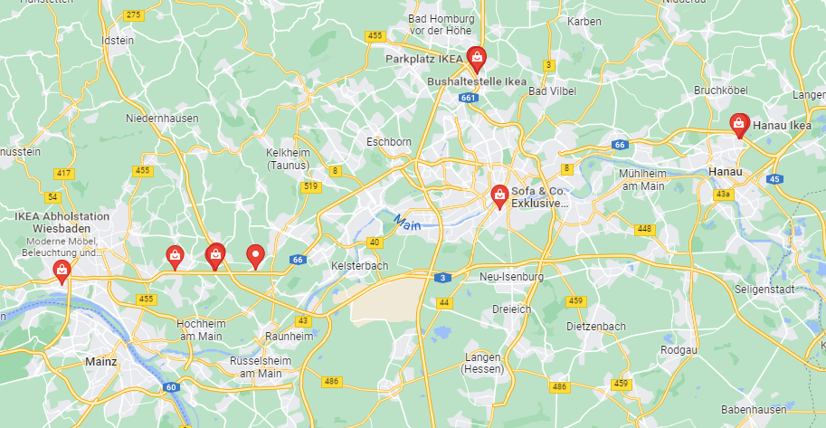
Und so toll die Daten der Nutzer auch sind, sie werden nicht sinnvoll genutzt. Wenn ich bei Google Maps "IKEA" eintippe, dann zeigt mir die App alle IKEA in der Umgebung an, übersichtlich auf der Karte. OsmAnd findet die IKEAs auch, und noch alles andere mit IKEA im Namen. Trotz der Option "Auf der Karte anzeigen" bleibt die Karte für mich aber leer. Ohne genaue Adresse ist OsmAnd für mich kaum nutzbar.
Aber gut, man hat eine Adresse eingegeben und die Berechnung ist abgeschlossen, wie ist die eigentliche Navigation? Hier bin ich etwas zwiegespalten. Ich mag die detaillierte Ansicht der Umgebung und die klare Farbgebung. Bunter als Google Maps, aber für mich super. Die Routen sind dabei aber nicht ganz optimal. Gibt es eine gesonderte Ausfahrtspur neben der Autobahn, dann wird man gerne darauf geleitet um diese komplett bis zum Ende wieder auf die Autobahn zu fahren. Stauumfahrung oder Berechnung des Verkehrs in die Dauer der Fahrt? Fehlanzeige. Und eines fehlt mir extrem: eine gekippte Ansicht. OsmAnd zeigt die Karte nur immer direkt von oben an. Gerade auf unbekannten Straßen schätze ich aber anhand der Strecke ab, wie ich zu fahren habe. Dafür ist die gekippte Ansicht von Google Maps erheblich besser.
Daten für Funktionen
Ist mir Google Maps die Herausgabe meiner Daten wert?
Schwierig zu entscheiden. In manchen Dingen, gerade bei den Details und der generellen Darstellung gefällt mir OsmAnd besser als Google Maps. Aber eine Navigation zu starten ist grausam und die Navigation selbst nicht optimal. Und hier könnte OsmAnd gerne auch die Daten der Nutzer verwenden, um den Verkehr zu messen - das geht sicher auch anonym.
Jetzt zum Knackpunkt: Da ich ein Android Smartphone inklusive der Google Dienste verwende bekommt Google meinen Standort in jedem Fall. OsmAnd setzt sogar in der Standardeinstellung auf die Google Play Services zur Standortbestimmung. Von daher bleibe ich aktuell bei Google Maps, da es im Alltag wesentlich bequemer zu nutzen ist, wenn die Daten eh bei Google landen. Der Standortverlauf ist am Ende auch ein recht nützliches Feature.
Mir ist aber bewusst, dass meine Standortdaten sehr viel über mich aussagen können, sollte sich diese jemand manuell anschauen. Arbeitsort, beliebte Orte, Abwesenheiten, alles ist damit erkennbar. Das ist derzeit der Preis der Bequemlichkeit. Eventuell lege ich mir bald ein iPhone zu, dann schaue ich mir die dortigen Optionen an.